Citybook
See Your City, Change Your City
by Ali Kargin
Abstract
Citybook is a civic engagement platform designed to help neighbourhood residents understand the often invisible systems—like traffic, electricity, water, and waste—that shape daily life and require shared responsibility. By making these systems more visible, Citybook supports informed, collective decision-making. Residents can explore questions such as: How does the traffic work? Where does your water come from? What happens to your waste? How is electricity generated and distributed? Are there service disparities linked to wealth? Everyday actions—like turning on a light—have wider environmental impacts.
Why
For a democracy to function, people need to understand the systems they live in, in order to take part in the conversation...I believe that this kind of understanding is a basic human right. For democracy to thrive, people must understand the systems they live within. Citybook offers tools to build awareness, challenge myths, and empower residents to help shape more inclusive, sustainable neighbourhoods. Our lives are shaped by innumerable systems that we never see, and rarely have control over. I sees this as a problem that can be solved, at least partially.
How
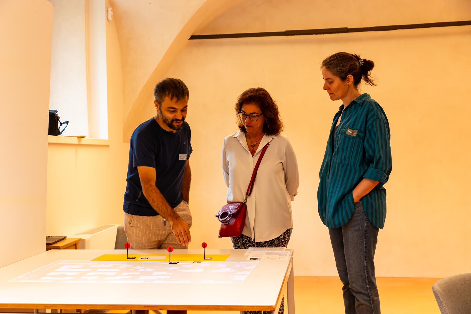
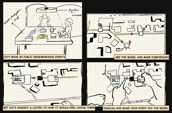
"Citybook" uses interactive projections to make the invisible systems of a city visible, giving residents a greater say in how they might be designed and modified for the benefit of all. The current implementation is only exploring the question of what would be the effect of introducing a 30 km/h speed limit in our neighborhood. The map content, representing the neighborhood, is projected onto the table, and the user interacts with it via physical objects (e.g., speed limit signs) and observe the changes via different lenses.
One way to gain insight is through the data lens, which provides more context. Another is through the diagnostic lens, which lets users experience what it might feel like to live there by listening to the sound of the streets. The idea is that, by using different lenses, users can gain multiple points of views. Citybook can be integrated into urban and public spaces to provide insights into the invisible systems we live in and are collectively responsible for.
Research
During research, I figured that young people have concerns about these too. They want to understand these
complexities. They were mentioning how understanding things like economics and ecology was effective for
them to participate in life.
The insight is: Seeing and understanding systems is effective. It allows people to participate.
*“I still think that that class helped me understand more also about how everything in
the world works because currently we live in a society that works on money and with money as an
objective so
understanding how that money flows is something that really helped me understand things”, Mauro
“Ecology class was really important. I understood more about the environment”, Pamela
You can't be part of something you can't understand; you will be a bystander -- you won't be able to contribute and be a part of transformation. So than the questions is how do we see and explore the systems we live in, so that we--all citizens--can be co-designers of our society” ? Scientists have microscopes to see the "micro systems" or processes, and have telescopes to see the planetary systems, but what do we, as citizens ,have to explore and make our own understanding of these systems ?
Design challenge
How can we see the systems that govern us? And how can we even create change if we can’t see them? Our basic needs are governed by systems—laws, policies, and markets—that we never voted on, yet they shape our daily lives, our identities, even our survival. And yet, we have no visibility into them. We’re not just living; we’re constantly navigating these invisible systems. I believe we must see and reveal these hidden layers if we are to transform them.
- HMW see and explore the systems we live in, so that we--all citizens--can be co-designers of our society ?
- How can we see and explore the systems that governs us ?
Let's be more specific and consider this case: How did this road sign get here?
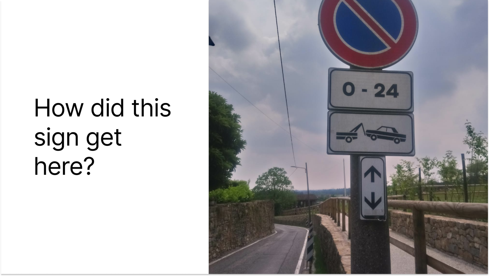 *This is a "Divieto di sosta" sign in Italy.
No parking at any time (24/7) in both directions from this point on. Illegally parked vehicles will be
towed.
*This is a "Divieto di sosta" sign in Italy.
No parking at any time (24/7) in both directions from this point on. Illegally parked vehicles will be
towed.
Let’s trace it back through its systems and layers. The sign is interface that allow us interact with traffic,we,pedestrians and drivers interacting with it without knowing anything about processes involved in the systems
- Residents or Tourists complain—maybe a near accident, narrow roads or unsafe parking
- Collect data—traffic department reviews the case, a recommendation is passed to city's traffic management office
- Authorize—a city ordinance is issued for a parking zone
- Define the form—design process
- Build the sign—production process
- Place the sign—installation process
- Now the sign becomes the interface
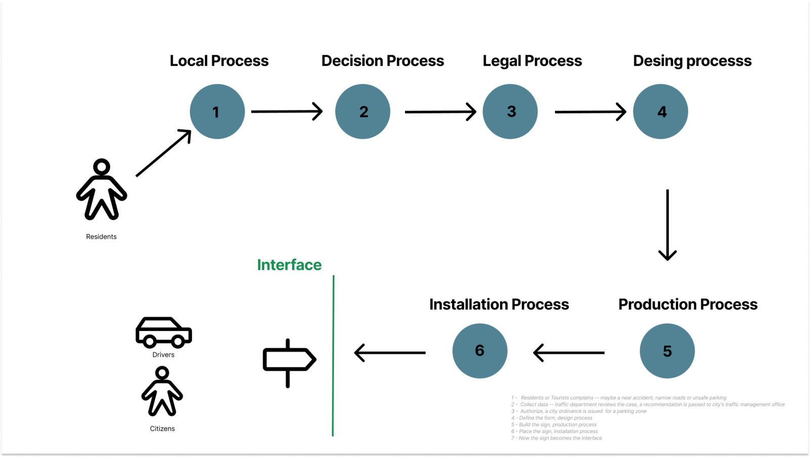
How can we reveal these proceses? Can we have something like systemscobe, sociascope so that citizen can participate to desing of their environment
Concept
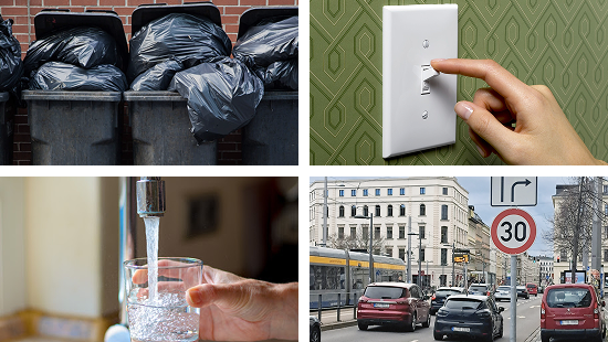
I started to think about touch points in cities. We have a very vague understanding of these touch points and their effect. Where does your trash go? Every time you put out trash, do you take a remote action somewhere? Where does water come from ? Where is the electricity coming from? How is it generated ? How does the traffic system work and what is the effect of speed limits?
 - Try to think the tool as a touch point in that process.Think about what’s before and what’s after
when people using the tool, how can we design that discussion?
- Try to think the tool as a touch point in that process.Think about what’s before and what’s after
when people using the tool, how can we design that discussion?
- Turning infrastructure (the road) into a shared conversation point.
- Encouraging design literacy: speed signs aren't just rules, they're values encoded.
- It hints that we can change the system — not just live under it.
- How to balance information(data) with immediate feelings for people ?
- How can you give them those immediate feedback in 2 minutes let people feel the changes via model
- How it would feel to live in this environment after changes ( maybe birds are coming when you add more
trees and you can hear the sounds)
It’s a medium for residents of a neighborhood to see the invisible processes and be participants in the
changes of their neighborhood. This will foster civic engagement, and they will have a "formal language" to
produce more nuanced arguments.
 Citybook is a civic engagement medium for the residents of a neighborhood;
- to give them insight and awareness into invisible systems (traffic, electricity, water, etc.) that we live in and are responsible for.
- to support participatory, bottom-up, collective decision-making
- to enable model-based constructive conversation, not based on ideologies
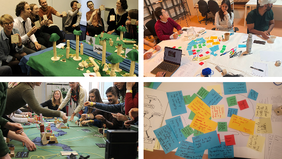
Prototypes
Static model
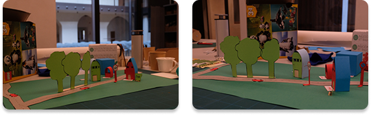
I started to build something like a model, even though it was static, it helped me to form some ideas. I noticed that i had no idea about the traffic -- it helped me to "create" some senarios and to communicate the concerns and constraints.
Lenses
A small simulation tool to prototype to prototypes. User can create a neighborhood zone and add traffic route to see and explore and see the effect of speed limit on their environment* *Naive assumption is that the number of cars and the speed affect the environment in a way that you could hear the bird sounds to give the impression of the healing of the environment in case of introducing a speed limit on the zone. Prototyping how to use bird sounds or other environmental indicators as part of the interaction.
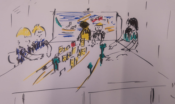
Projection mapping on physical model
Testing projection mapping on physical "models“. First idea was to use 3D printed models and projecting computational content on those, but didn't have enough time and it was creating other problems(shading and interfering with camera), so I decided to project and use digital map(2D) as content, and the interaction with the map happens via physical tokens(speed limit signs) * *I was playing with this lib p5.mapper, the missing thing is I needed dynamic mapping
Tangible interaction
Map is projected on table, the digital canvas, and the interaction is happening with physical tokens, testing if the user can select a road on the map and introduce a speed limit on the road, when the user put the toke on the road that means introducing a speed limit on the the road.
The first integration of the parts, projection mapping, visual recognation of tokens and having the intented interaction with physical harware(tokens) and digital canvas.
Agent-based modelling
Using GAML language to create a realistic model. This is still in process.
From plan(2D) to 3D experience
Dynamically ray casting from an image, intented as a mini map, a 3D visual experience of the street.